
The Sinemurian cuesta and the Rhaetian cuesta
Often, the Belgians of the center and the north of the country, call "Ardenne" all the south of Belgium, without distinction of the regions. However, much more than by the differences of dialect, even of character or culture of their inhabitants, the Ardenne and the Gaume (or Romanesque part of Belgian Lorraine) are distinguished by their underlying geology.
In the Ardenne, the layers which outcrop are those of the primary Paleozoic basement (approximately between -540 and -250 million years ago), while the south of the province of Luxembourg is the only Belgian region whose outcropping geological layers date from the secondary era (more precisely Jurassic period). It is part of the "Paris Basin", which was occupied by a vast inland sea. From the Triassic period (-250 million years), the sea began to fill in with the deposition of sediments resulting from the erosion of the massifs, resting on the southern edge of the primary Ardennes basement. As this filling took place in several phases, with withdrawals from the sea, followed by several brief returns, several different layers were deposited, alternating hard rocks, like sandstone or limestone, and loose rocks, like the clay, marls, shale or sand. Over time, erosion has therefore sculpted a remarkable topographical landscape, showing a relief in asymmetrical sawtooths or cuestas. The soft layers, easily eroded, are fertile valleys whereas, on hard rocks slightly eroded, the coasts or cuestas are often wooded.
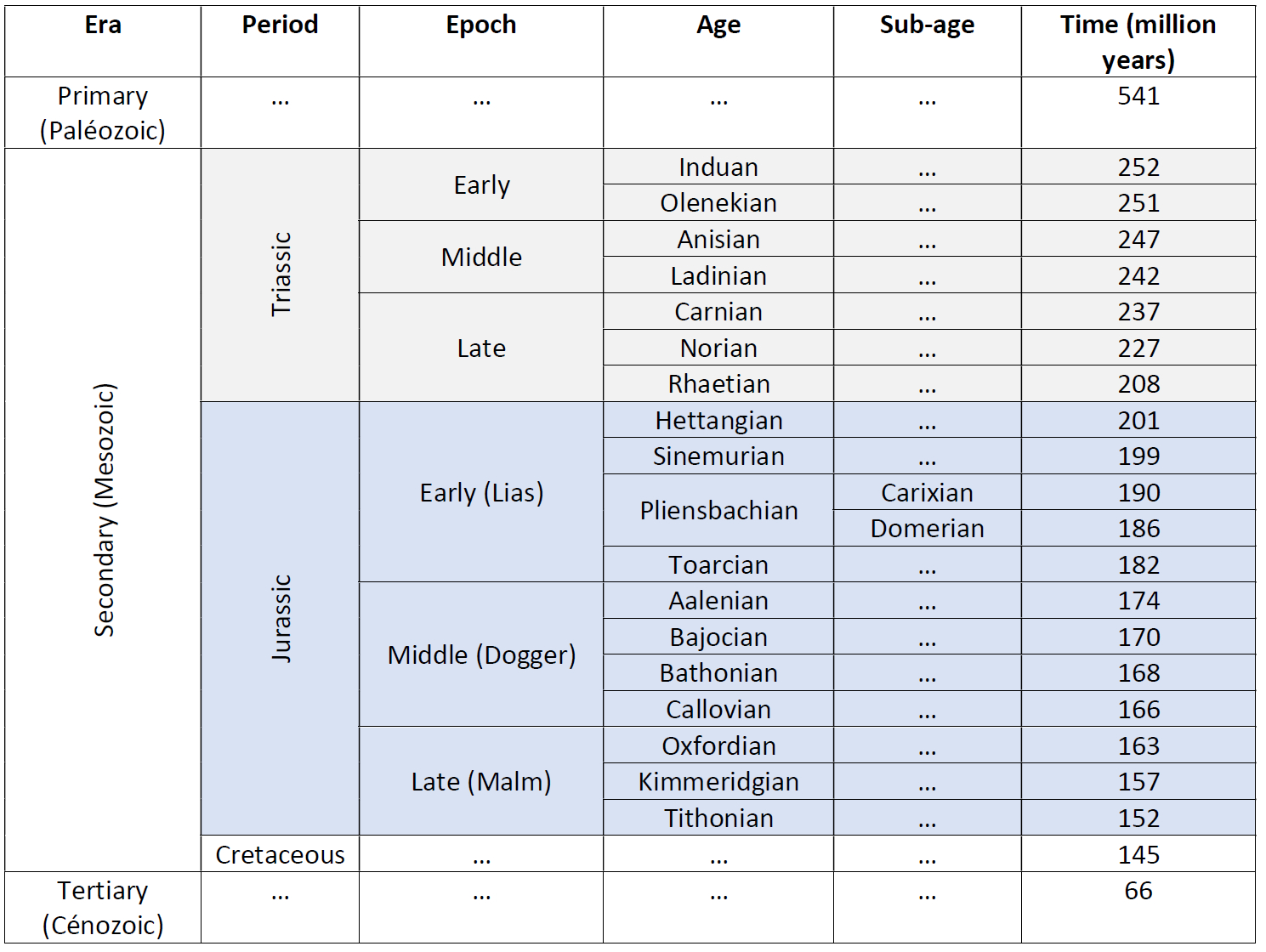
Without going into details, a small table can be useful to recall the geological time scale and more especially for the secondary era which interests our regions.
In Gaume, we usually identify three main cuestas.
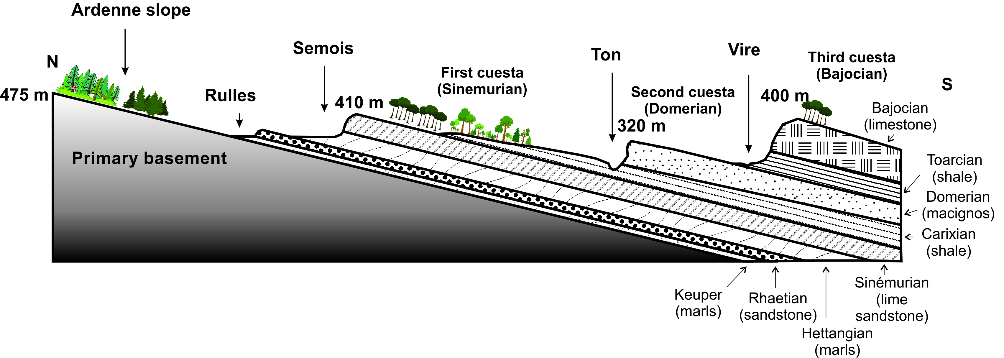
The first cuesta is the Sinemurian cuesta. An inclined layer of soft marl, deposited 200 million years ago (Hettangian age/stage), was dug by the Semois and its hydrographic network. On this marl, during the geological age of the Sinemurian (between 199 and 190 million years), a layer of harder sandstone was deposited, which was little eroded. It forms the crest of the cuesta, which points at an altitude of over 400 meters. Between the depression formed by the Semois and the ridge therefore formed a steep front. By its inclination, the hard layer forms a gentle slope towards the south, called the reverse of the cuesta.
Later (Carixian sub-age), layers of marl and schist, tender, were deposited on the Sinemurian sandstone. They are notched by deep valleys: the Gros-Ruisseau, the Chevratte, the Soye ... etc. and more particularly the river Ton, which dug a depression ending in the south the Sinemurian cuesta. At the time of the Domérien sub-age, between 186 and -182 million years ago, a hard layer of limestone sandstone, also called "macignos", was again deposited, forming the crest, then the back of the second cuesta, along to the south by the Vire river, which has dug its bed in a softer layer of schist again.
Finally, during the Bajocian age, between -170 and -168 million years ago, a hard limestone layer, little eroded, formed a third cuesta as far as the French border. These three cuestas, the Sinemurian, the Domérienne (or Macignos) and the Bajocian, are therefore characterized by a steep front to the north, a ridge, then a back, sloping gently towards the south. They are bordered by three rivers: the Semois, the Ton and the Vire, which form their limits.
But in Etalle, the situation is a bit special.
In the municipality of Etalle, we should therefore be essentially at the level of the Sinemurian cuesta, with, to the south of the Semois, respectively a front, a ridge, then a reverse ending in the Ton in Ethe.
However , this cuesta has an important peculiarity, since it disappears from west to east between Tintigny and Vance and is therefore almost non-existent in the municipality of Etalle. This could be explained by a sedimentary gap at this place, that is to say the absence of a layer which, elsewhere, protects the underlying sandstones from erosion, but which, between Tintigny and Vance, is not present, which has resulted in erosion and truncation of the Sinemurian cuesta crest, leaving instead a vast marshy plain.
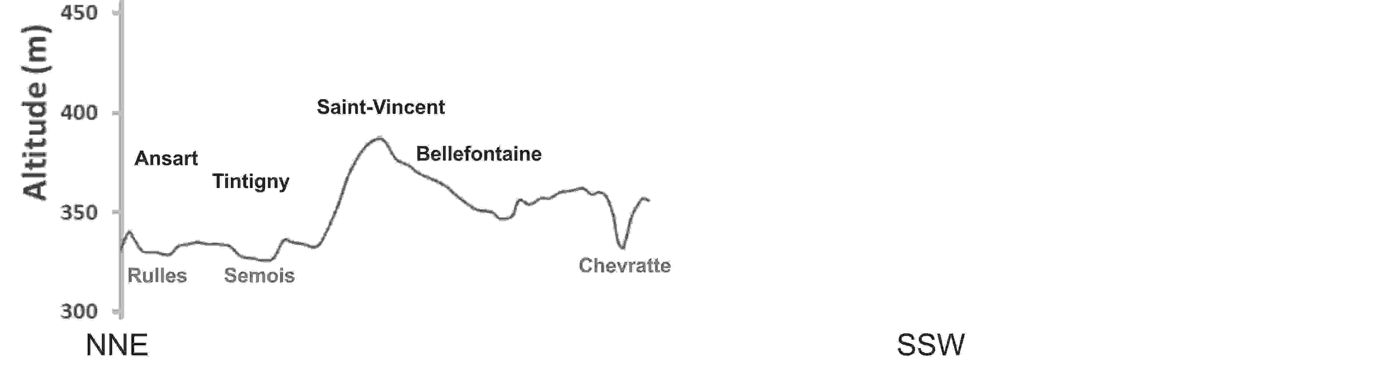
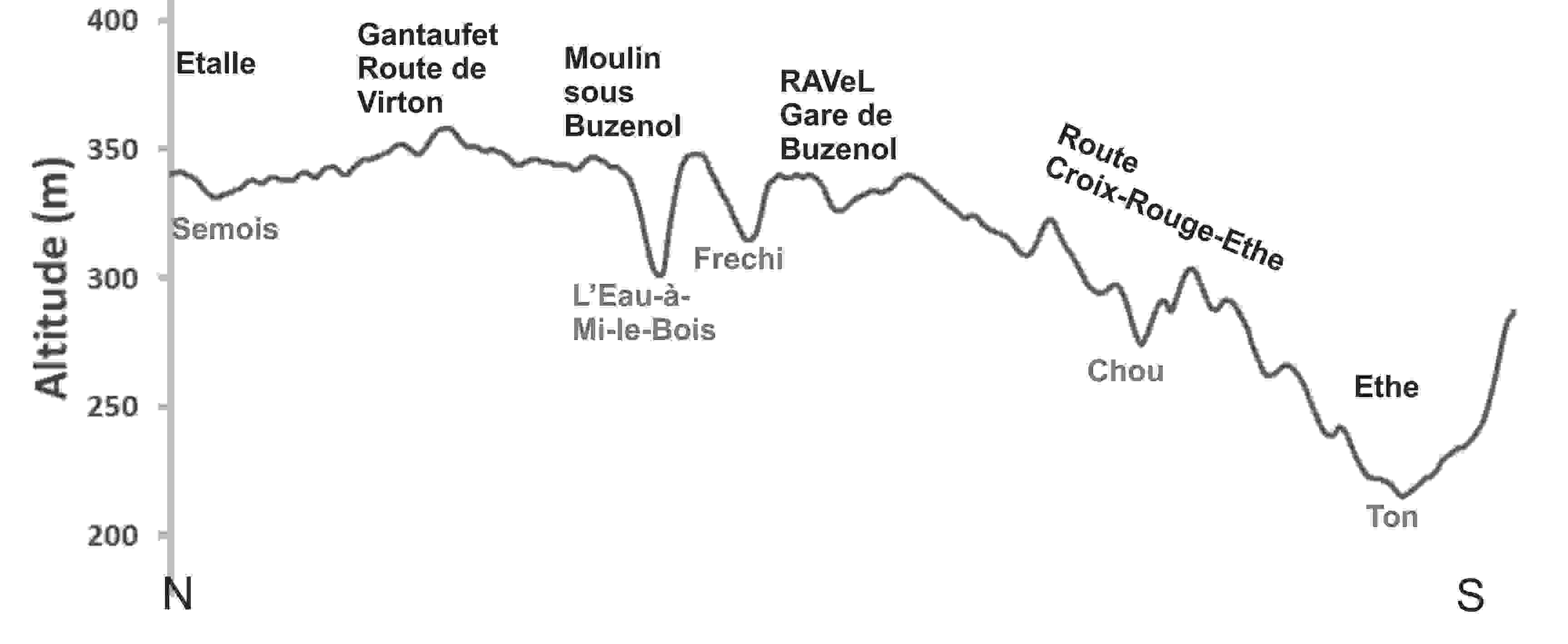
At the level of the municipality, the cuesta therefore presents practically no steep front south of the Semois, as can be observed for example between Tintigny and Saint-Vincent-Bellefontaine, with an average slope of almost 6% (see section of 7 km NNE- SSW), but, on Etalle, only an inclined reverse, to the south of the Croix-Rouge-Buzenol-Chantemelle line towards Ethe and Saint-Léger (see section NS of 12 km).
So, is the cuesta in Etalle a legend?
Not really: in the texts relating to the municipality of Etalle, the Sinemurian cuesta is often mentioned, including on our website, to locate, for example, elements of the natural heritage (marshes, mardelles, etc.). Indeed, if the front and the ridge are only "virtual" there, the chronology and the hardness of the underlying geological layers nevertheless remain consistent with the rest of the cuesta.
The Rhaetian cuesta
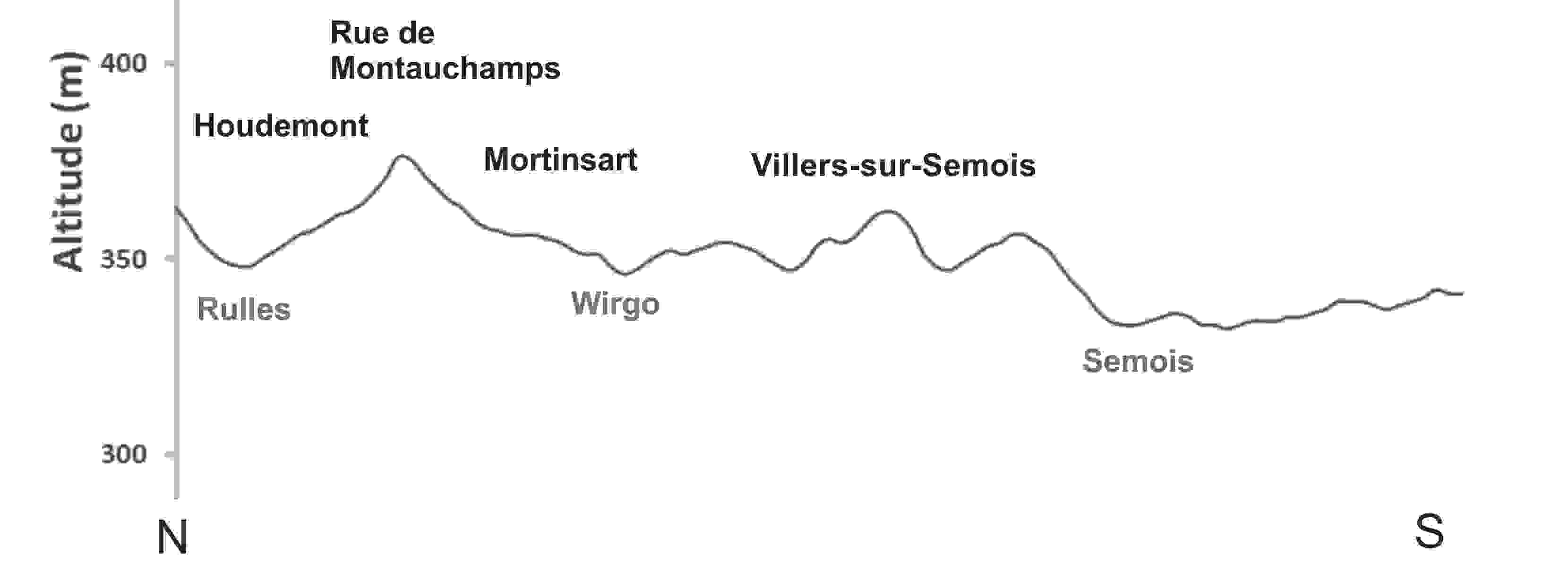
However, there is another cuesta in the municipality, which is often forgotten, because it is less extensive from east to west. It is called the "little Rhaetian cuesta". North of the Sinemurian cuesta, still going back in time, just on the primary base of the Ardennes, a layer of sandstone was deposited during the Rhaetian age (between -208 and -201 million years ago) over a layer of soft marl which was dug by the Rulles. And so, between Rulles and Semois is this small cuesta with a front, visible for example at the exit of Houdemont towards Mortinsart (slope 3.5%), a ridge at the level of the roads of Montavaux, then Montauchamps, which pass to above the GSM antenna north of Mortinsart and a gently sloping backside to the Semois. But this cuesta is only present for a few kilometers from east to west between Ansart and Habay-la-Neuve.
Global view of the relief
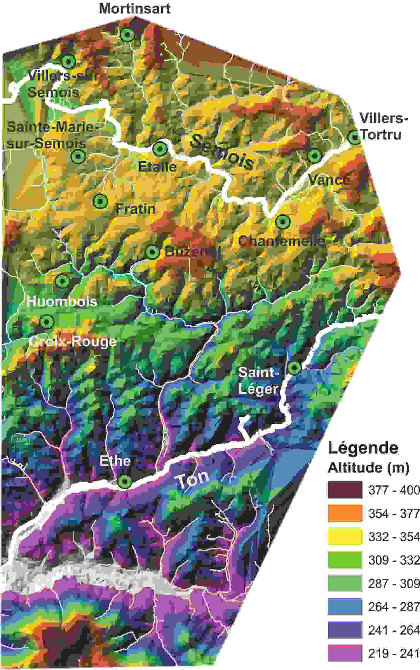
The entire relief of the region south of the Semois can also be viewed in the figure where the altitude is represented in the form of a color scale (in legend). Once again, the cuesta front south of Etalle is not visible there.
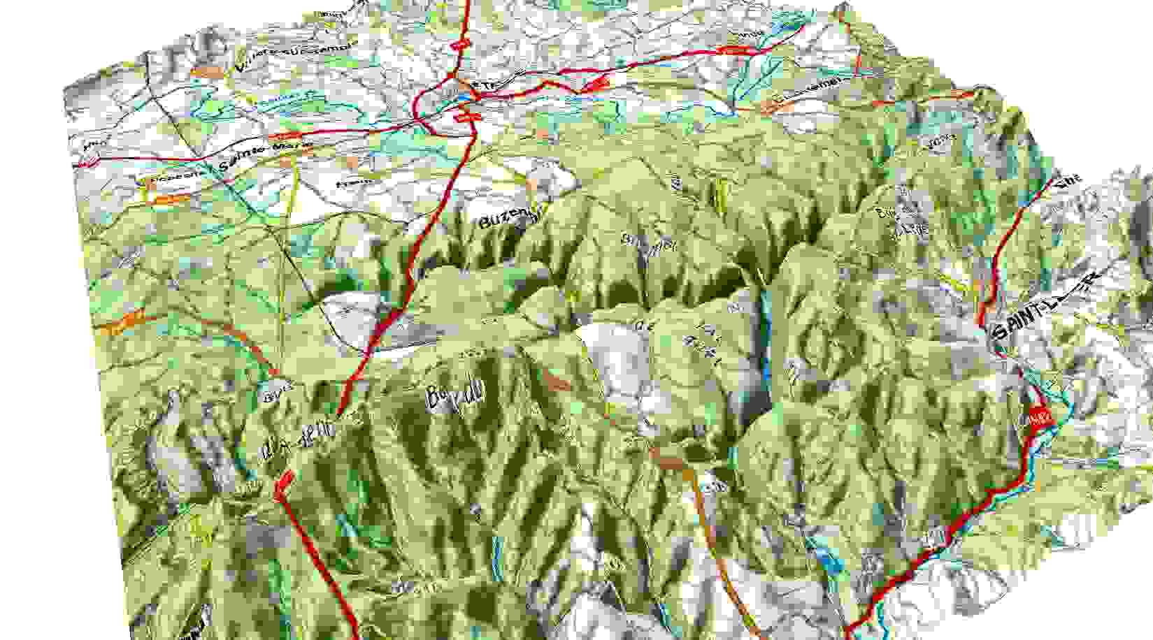
Another way to see the relief is to "drape" the map on the support in 3 dimensions. In this figure, we can see above all the deep valleys carved out by the Rouge-Eau, the Gros Ruisseau, the Neuve-Forge and the Laclaireau streams in the back of the Sinemurian cuesta.