
Fortified castles in the municipality of Etalle?
In the municipality of Etalle, some castles are still visible today, sometimes in poor condition, like that of Villers-sur-Semois, sometimes very well preserved or restored, like that of the Grosse Tour in Etalle or that of Sainte-Marie or again the Thiéry or Bru manor-farms in Vance. But history tells us that other castles once existed (besides the Roman villas) and have now disappeared. In fact, in feudal times, each seigneury had its stronghold or castle.
In Etalle
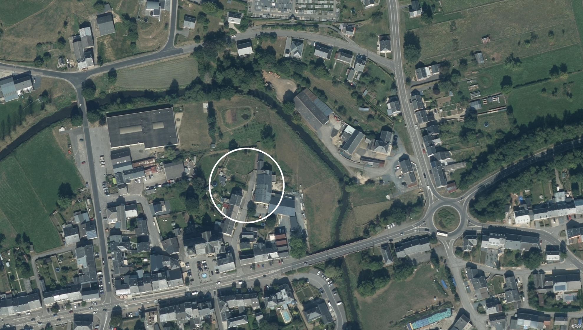 Besides that of the Grosse Tour (Big Tower) or Castle of the Margelle, there was another castle, seat of the ancient family of the Counts of Chiny.
It was located behind the church, at the end of the rue de la Radelette.
Besides that of the Grosse Tour (Big Tower) or Castle of the Margelle, there was another castle, seat of the ancient family of the Counts of Chiny.
It was located behind the church, at the end of the rue de la Radelette. By clearing the terraces, in 1848, we discovered, at a depth of 2m50, about fifteen skeletons, weapons, urns and Roman coins. Under a tombstone without inscription, one also found bones and a long sword. In 1993, the current owner of the land, near the Semois, reported the presence of stonework. The excavations that followed revealed walls, ditches, the base of a rectangular tower, etc. It was indeed the castle, of which it was possible to restore the general layout: a circular ensemble of 80 meters in diameter surrounded by a ditch flooded by the Semois.
The castle was built around 1066 by Arnould II de Chiny. With the strongholds of Vance and Villers-sur-Semois, it formed a line of defense between Barrois and Luxembourg. Also, he had many seats to support, when quarrels of interest pitted the two countries at grips. Arnould II, Count of Chiny, had built and fortified it; then he had entrusted the care of it to one of his faithful knights, who became the linchpin of the seigneurial family of Étalle.
Still in Etalle
 A third castle also existed in Etalle: the castle "Mouche d'Ethe".
This stronghold was built in 1573 by Geoffroy d'Ethe on the current road to Virton, a little before the junction of the rue du Bois, probably near the fork that begins the rue du Harret.
A third castle also existed in Etalle: the castle "Mouche d'Ethe".
This stronghold was built in 1573 by Geoffroy d'Ethe on the current road to Virton, a little before the junction of the rue du Bois, probably near the fork that begins the rue du Harret. At the time, it contained about 50 ares of land and was surrounded by ditches filled with water, with a drawbridge and two towers.
The name "mouche" (mouche could mean "fly" in French, but not here) seems quite difficult to understand. It could possibly be a variation of Old French musse or "hiding place", hence "withdrawn place", due to the attraction of the French word mouche. One might think that this was the place where Geoffroy d'Ethe wanted to retire, away from Ethe.
This stronghold is mentioned in an act of 1604, but appears as a "ruin" on a plan of the center of Etalle in 1646.
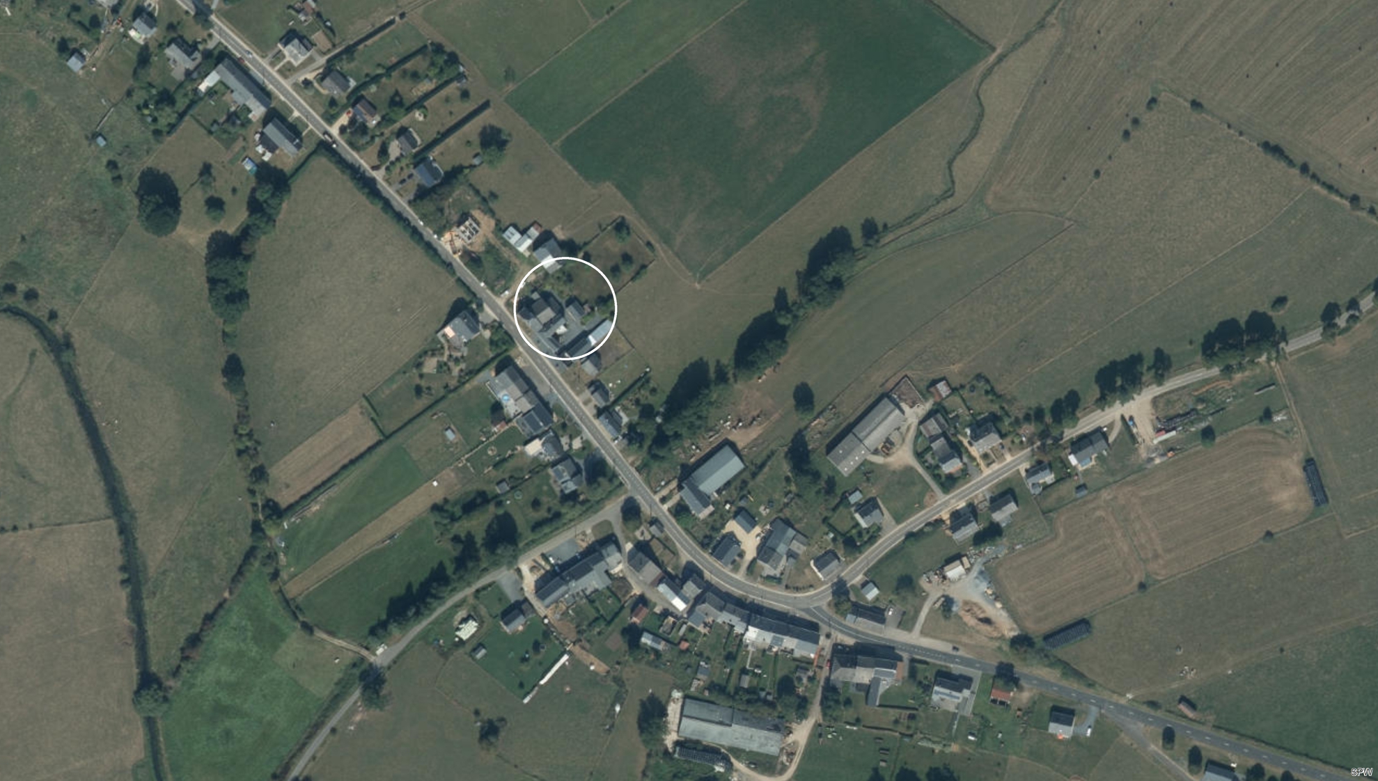
In Villers-sur-Semois
 The castle still visible today would have been built by Henri Henriquez in 1712.
But it seems that there was previously a stronghold of which no details are known.
It was located, it seems, in a fork between the current rue du Tru and a path which passed at the edge of the wood of Danremy to arrive at the Malpierre.
The castle still visible today would have been built by Henri Henriquez in 1712.
But it seems that there was previously a stronghold of which no details are known.
It was located, it seems, in a fork between the current rue du Tru and a path which passed at the edge of the wood of Danremy to arrive at the Malpierre. It seems to have been of some importance, especially around the 12th century, since, according to some historians, it was, with the castles of Etalle and Vance, one of the most solid points of support for the line of defense between the Luxembourg and Barrois, which were often at war in the Middle Ages. This stronghold, called "the Trux", was the counterpart of the village, the pendant of the church, located on the other side of the small valley of an intermittent stream which crosses the village from north to south.
It is probably from this house that the Trux family takes its name. This family was very influential in the Middle Ages, until the 18th century: in Vance, Longwy, Stainchamps and Etalle.
It is difficult to locate this castle exactly today. Tandel mentions it in his work on Luxembourg municipalities: "in the middle of Villers is a piece of land (cultivated now, and belonging to the Aremberg family) raised from 5 to 6 meters; it is said to be the site of a castle which would have belonged to a lord named du Trux; there is still an old section of wall which prevents the land from descending on the path; is it a remainder of the castle or a perimeter wall? One has never done any excavation; the part of the locality that surrounds this land still bears the name of Tru. "
In Sivry
 There was also a stronghold, located at 211/2 and 213 in the main street of the village.
Formerly quadrilateral, only one wing is still in place perpendicular to the road, with a short return to square on it.
There was also a stronghold, located at 211/2 and 213 in the main street of the village.
Formerly quadrilateral, only one wing is still in place perpendicular to the road, with a short return to square on it. This castle was probably the stronghold that Thibaud de Bar, in 1342, declared to hold in stronghold. It was mentioned in 1270 in a charter concerning an arrangement between the counts of Luxembourg and Bar.
The fortified house was held by Clément de Sivry in 1604, then by the Comte de Monceau in 1750. In the 16th century, the house was also probably inhabited by Rémy Jacquot, lieutenant-provost for the Duchy of Lorraine. It is the tombstone of her daughter Marie and her son-in-law François de Senocq which leans against the back wall of the church in Etalle. The fortified house was also occupied by André Blanchart, who died in 1729 following a fall from his horse. His epitaph can be found at the back of the church in Etalle.
In Vance
 In Vance, historians even mention a "fortified castle".
It was probably located not far from the current cemetery, perhaps between the Semois and the Agri-Vance building.
In Vance, historians even mention a "fortified castle".
It was probably located not far from the current cemetery, perhaps between the Semois and the Agri-Vance building. A few years ago, a mound still marked the place where the dungeon was located, because it was the rule to build it on a natural or artificial mound called "motte" ("mound"). During work carried out in 1861 to rectify the course of the Semois river, the remains of a stony path that served the castle were found there. The Semois provided water to feed the ditches and the nearby swamps made it difficult to access.
It was the Lords of Vans who built this first Vance fortress, imposing by its mass and which was an important point of defense of the borders of the county of Chiny. The area of its site, including ditches, was about one "day", that is to say from 30 to 35 ares, which would indicate rather modest proportions.
The construction was probably to take place a little before the 1200s. Aubert de Vance certainly lived there around 1260 and the writings show that he had the appropriate strength and means. He was to maintain a garrison in the castle. It seems that the castle was burned in 1266 by the troops of the Count of Bar Thiébaut II, then rebuilt shortly after, in 1284, in its former location. Around 1350, the Lords of Vance were the Sires of Colmey. The locality "Le Coulmy", between the N83 and the Semois, north-west of the current Vance cemetery confirms that the castle was located there.
The ruins of Vance's first fortified castle were still visible in 1602, but they were described as "hovel of the old castle, long ruined". It seems that after its destruction, another castel was built nearby, opposite, near the Semois and the marshes which were to contribute to its defense. It was demolished by the French in 1656. Moreover, the location, near the presbytery, still bears the name "Au Château" (at the castle) today.
Still in Vance
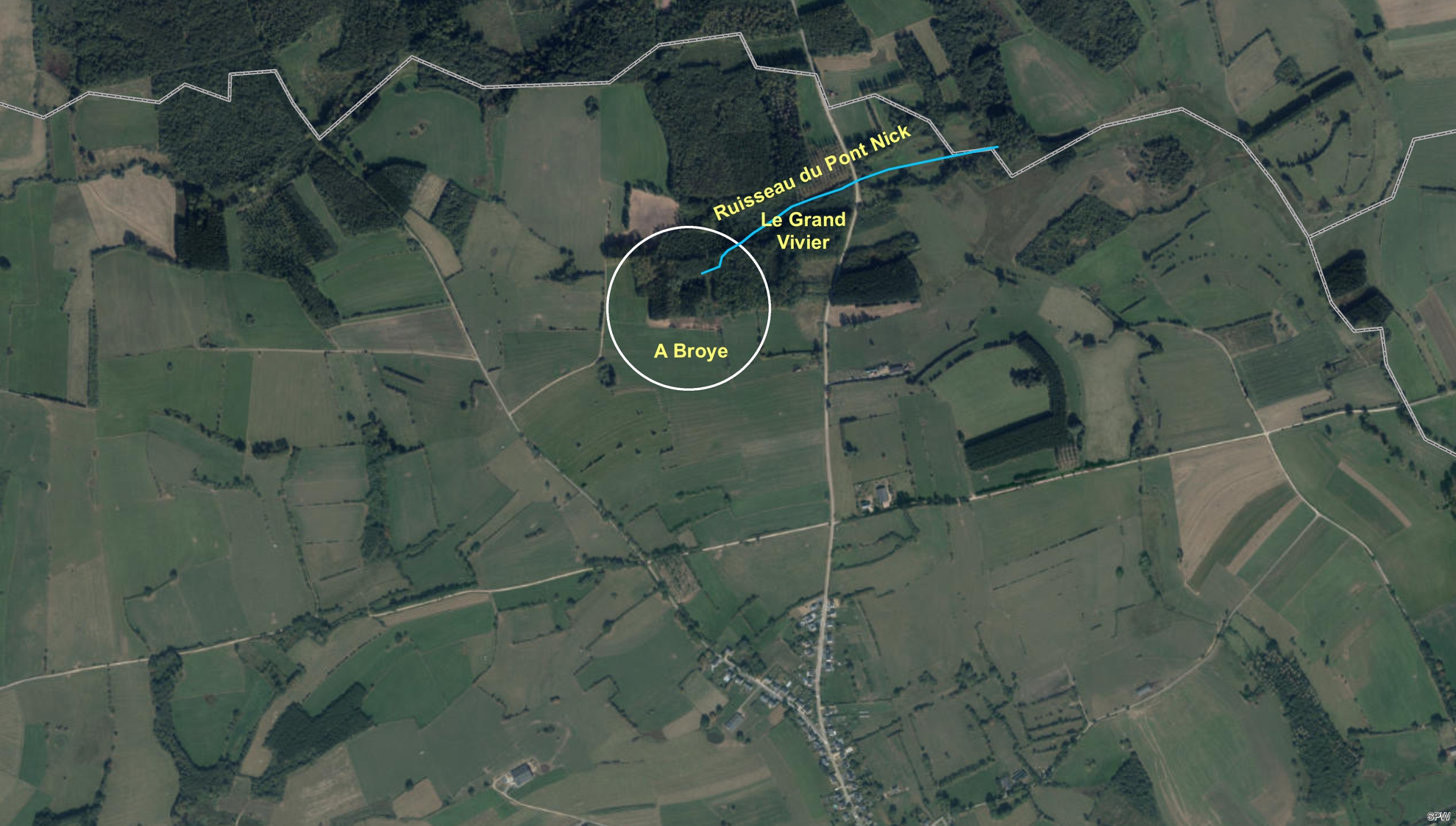 To the north-east of the village, a short distance from the border between the territories of Vance and Hachy, at the locality "à Broye", between the road to Habay and the extension of the rue Notre-Dame des Champs, to the north of the Roman road, the remains of another castle have been identified.
 The etymology seems to assign it a very ancient origin, contemporary or perhaps earlier than that of the first castle of Vance. "Broye", in Gallic dialect meant fortress, citadel. The name is found, with the same meaning, in two localities in the south of France.
At its location, there are small piles of debris and various materials. Excavations would perhaps make it possible to discover the substructures. Below, there was a pond in the place of "le Grand Vivier" ("the large fishpond"), the water of which was contained by dikes and the overflow of which would flow into the Pont Nick stream. We can assume that these waters once fed the ditches of the castle.
In Chantemelle
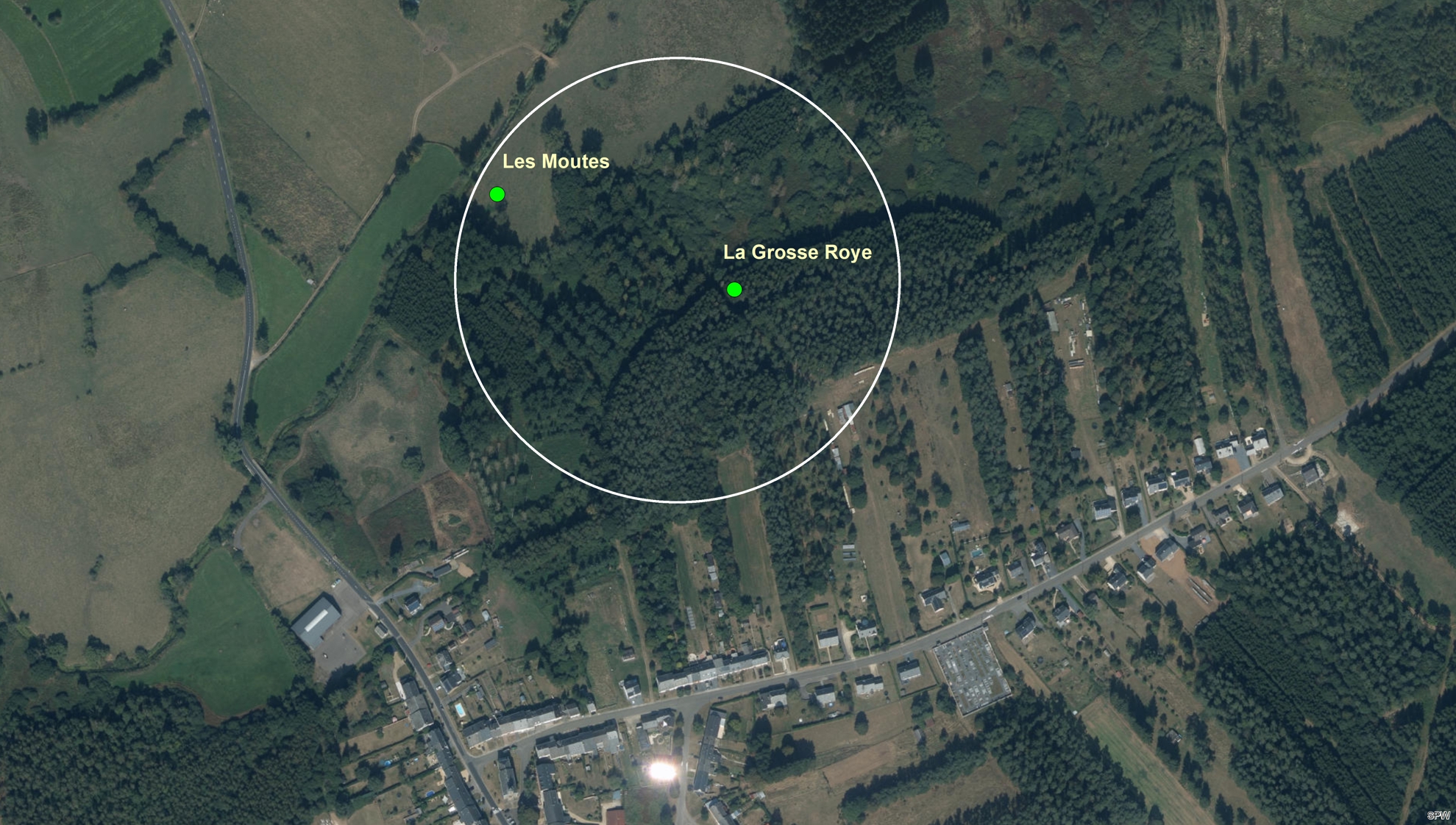 Between the Route d'Arlon and the Semois, at the localities "La Grosse Roye" and "Les Moutes", one would have found the remains of a castle.
 The place has kept its name "Les Moutes" and there is still a fairly considerable mound from which various debris have been extracted. The earth forming the mound is by no means the same as that of the surrounding land. We would still have found the foundations, buried 60 cm below the ground.
These are the remains that would mark the site of the castle of the Sires of Chantemerle destroyed in the 13th century. We do not know precisely how the lords of Chantemerle were dispossessed of their lordship and their castle destroyed. It seems that in 1255, following a disagreement over the possession of Aunois, Siger de Carpentier, Lord of Vance, succeeded in seizing the castle of Chantemelle and destroying it. The defeated chatelain was forced to flee after valiantly defending himself with his guard in the woods in front of his mansion. From that moment, Chantemelle had to recognize and pay homage to the lord of Vance.
The date of 1255 could be accepted as that of the destruction of the castle of Chantemerle, because it is from this moment that we no longer speak of them in the region.
So, can we speak of "fortified castles" that have disappeared in the municipality of Etalle?
The term "castle" evokes solid fortifications, with moats, drawbridge, keep, loopholes, ...
Perhaps it is exaggerated to use this term with regard to the castles of Etalle.
The term "stronghold" is probably better suited.
These buildings are not castles (castrum or castellum), but are more than simple residences (domus).
However, while in the German part of the country, the castles were perched on inaccessible rocks, and looked more like what one imagines to be a "fortified castle", in the Walloon part they sat in the valley, surrounded by wide ditches filled with water.
They were masses of masonry, in the form of towers or dungeons, which aimed less at elegance than at solidity, as in the Semois valley and especially in the current municipality of Etalle.
So were those of Etalle, Vance, Chantemelle and Villers-sur-Semois.
That of Vance in any case is often described as a "fortified castle".
Be that as it may, the feudal lords were not to feel too safe at this time of tensions between the County of Bar and the Duchy of Luxembourg.
In total, adding the fortifications of Montauban, there would have been a dozen such "castles" just on the territory of the current municipality of Etalle!
Bibliography
- Tandel, E. - Les communes Luxembourgeoises. Tome III. L'arrondissement de Virton. - Tome XXIII des Annales de l'Institut Archéologique du Luxembourg, Arlon: Institut archéologique du Luxembourg, 1890.
- Massonnet, J. - Histoire de Vance. - Tome XC des Annales de l'Institut Archéologique du Luxembourg, Arlon: Institut archéologique du Luxembourg, 1959.
- Tandel, E. - Notice sur les églises, abbayes, prieurés, châteaux et ponts présentant un caractère monumental ou archéologique, un caractère curieux. - Bulletin des commissions royales d'art et d'archéologie -37e année, Bruxelles, 1898.
- Prat, M. - A propos de la créàtion de la Société archéologique d'Arlon. - Tome II des Annales de l'Institut Archéologique du Luxembourg, Arlon: Institut archéologique du Luxembourg, 1849.
- Pruvost, A. - Notes sur la seigneurie de Vance. - Tome VI des Annales de l'Institut Archéologique du Luxembourg, Arlon: Institut archéologique du Luxembourg, 1870.
- Bertholet, J. - Histoire écclésiastique et civile du Duché de Luxembourg et Comté de Chiny- Troisième partie-Tome 6-Livre LIII - Luxembourg, 1743
- Liégeois, J.E. - Notes manuscrites insérées dans l'histoire du Duché de Luxembourg et Comté de Chiny du P. Bertholet par T.H. Welter, curé à Ethe en 1784. - Tome VIII des Annales de l'Institut Archéologique du Luxembourg, Arlon: Institut archéologique du Luxembourg, 1874.
- Mardaga, P. (ed.) - Lorraine, villages, paysages. Ensembles ruraux de Wallonie. - Liège: Ministère de la Communauté Française, 1983.
- Goffinet, H. - Les comtes de Chiny. - Tome X des Annales de l'Institut Archéologique du Luxembourg, Arlon: Institut archéologique du Luxembourg, 1878.
- Goffinet, H. - Mélanges. - Tome XIX des Annales de l'Institut Archéologique du Luxembourg, Arlon: Institut archéologique du Luxembourg, 1887.
- Lenoir, N.J. - Histoire de la prévôté d'Etalle et de la Seigneurie de Sainte-Marie. - Imprimerie des Amis de l'Ordre, Namur, 1909, p. 167.
- Hittelet, M. - La terre d'Etalle. - Etalle, 1999.